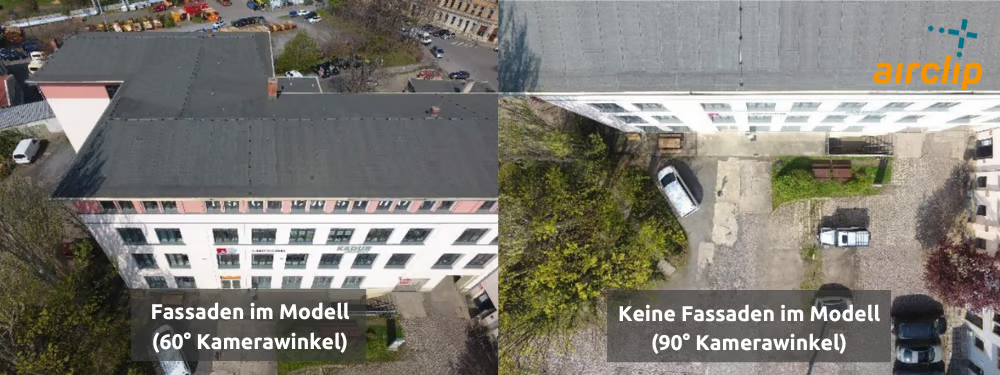
Left, a 60° camera angle: the façade makes it into the model. Right, 90°, straight down: only the roof.
At a glance
Altitude
30–60 m
Camera angle
90°, straight down
Capture
still photos, no video
Mode
mapping (DJI Pilot 2)
Photos per flight
few
Area
draw it as large as you want it in the model, with a little margin: the satellite map is not accurate to the centimetre
Common questions
What is the area route without oblique images for?
Everything you see from above: construction sites, storage yards, the volume of stockpiles, roof surfaces and the orthophoto, the rectified, true-to-scale top view. Because the camera points straight down, it is the fastest of the four flight patterns per area.
Why are the façades missing from a nadir flight?
A camera pointing straight down does not see walls. Façades appear only as a thin edge in the photos and end up distorted or missing in the model. If buildings are to come out with their sides, use the area route with oblique images.
How high do I fly the area route without oblique images?
30 to 60 metres above ground. For a single property, around 35 metres is a good rule of thumb: high enough to clear most trees, close enough for plenty of detail. Lower makes the model more accurate, but you get more photos and a longer flight. Too low over a tall roof gets risky, because the photos overlap too little up there. Fly large areas at 50 to 60 metres or higher.
Can I create an orthophoto from the flight?
Yes, that is one of the main purposes of this pattern. Airclip Cloud delivers the orthophoto as a GeoTIFF that you bring into QGIS, PV*SOL or another GIS.
Do I need RTK to compare volumes?
Yes, as soon as you compare two flights, say the state of a landfill a quarter apart. Both datasets have to sit exactly on top of each other. If one is just 10 centimetres too high, you get many cubic metres of fill or cut that never existed.